| |
|
Sun or Snow this Holiday Season? Arizona Has Both!
|
| |
| |
|
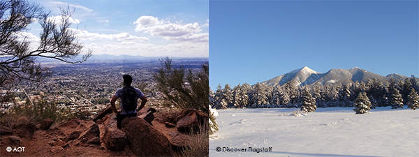
Thanks to its diverse geography, winter is an ideal time to visit Arizona. If you are looking for a winter wonderland as well as fun in the sun, then look no further. With high elevations in the north, northern Arizona enjoys a snowy winter. And, thanks to low elevations in central and southern Arizona, there is also plenty of sun and outside fun to be had in the Sonoran Desert! Here we highlight some fun snowy spots and some great sunny hikes you can do on a winter trip to Arizona.
|
|
| |
|
Tis the ski-son to be jolly!
|
|
| |
|
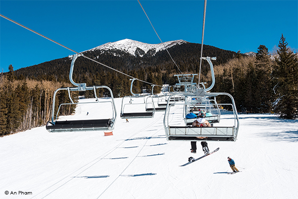
From December through to March, when Arizona's mountainous regions hit their wintertime season, you won't find better snow-or alpine recreation-outside of the Rockies! If you are searching for skiing in Arizona, look no further than Flagstaff and Arizona Snowbowl Winter Resort. Located less than half an hour from historic downtown Flagstaff, and only 2 hours from Phoenix, Snowbowl is the only resort that offers views of the Grand Canyon. New for this ski season is the Arizona Gondola, Arizona's newest high-speed lift.
|
|
| |
|
| |
|
Skiers and boarders of all levels can enjoy more than 50 trails, as well as bowl and tree skiing; and a special adaptive programme which gives enthusiasts of varying abilities the chance to hit the slopes with confidence. There are also three terrain parks for freestylers who want to hone their skills.
|
|
| |
|
Northern Arizona's White Mountains can lay claim to Arizona's other great ski mecca: Sunrise Park Resort The snow trails are the main attractions here and the area's 65 runs make it the largest Arizona ski resort. Experts flock to Lupe's 1,400-foot vertical drop and the multiple black-diamond trails off Cyclone Circle, one of the resort's three peaks. But Sunrise Park really shines for the intermediate and beginning skier and snowboarder, with long lazy runs like Crown Dancer and Spirit Trail providing plenty of space to work on turns and stops. The ski school offers both group and private lessons and caters to experienced adults as well as younger skiers and beginners.
|
|
| |
|
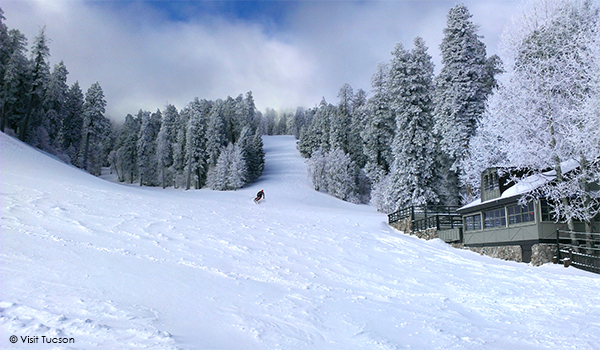
Arizona's big resorts aren't the only way to enjoy a winter thrill here. Mount Lemmon Ski Valley, a 22-trail snow park located near Tucson, is the southernmost ski area in the United States. This intimate ski area includes a casual indoor restaurant, a fudge shop, and a general store with a gift shop in the small mountain town of Summerhaven.
|
|
| |
|
| |
|
For snowshoeing, snow-bike riding and cross-country skiing adventures, Arizona Nordic Village in Flagstaff offers 25 miles of multi-use trails, as well as ski rentals and lessons if you're new to the sport. They also have rustic cabins and cabins for rent. You'll find more backcountry relaxation at Hannagan Meadow Lodge near Alpine. The lodge itself boasts cosy accommodation, but the real attraction is outdoors. Cross-country skiers and snowshoers will love the free trails that start right at the lodge and flow out into the Apache-Sitgreaves National Forests. Ice fishing, sledding and local events add to the wintertime smorgasbord.
|
|
|
With millions of acres of protected land, the number of hiking trails in Arizona is enormous. The only thing more impressive is the variety of scenery that hikers can enjoy, particularly in the Sonoran Desert. Because we couldn't possibly cover all of this area, here is a snippet of perfect hikes for Arizona's balmy winter months. And, yes, the weather may be near perfect, but don't forget to pack some water for your hikes - and maybe a sweater for the cooler morning/evening temperatures.
|
|
| |
|
The 14.3-mile National Trail is the consummate South Mountain hike. One of the largest municipal parks in the country covering 16,000 acres, South Mountain gives you room to roam. In addition, South Mountain is rich with environmental and cultural history. Located in the foothills is Mystery Castle which was built in the 1930s by Boyce Gulley for his daughter Mary Lou. The castle, which took 15 years to build, has 18 rooms and 13 fireplaces.
|
|
| |
|
If you're not looking for an all-day adventure, hike east a few miles along the trail from Buena Vista Lookout to Fat Man's Pass. A narrow natural tunnel arcs over the trail and makes a good turn-around point.
|
|
| |
|
Camelback Mountain, Phoenix
|
|
| |
|
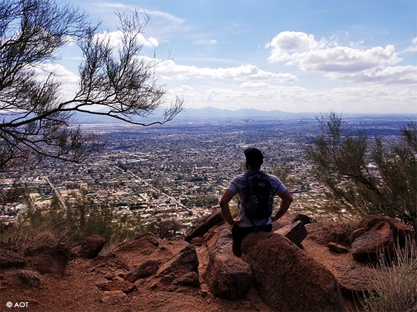
"Hike" may not be the best verb to describe the 1.2-mile Echo Canyon trail (or Summit Trail) that ascends 1,264 feet to the top of Camelback Mountain. A better verb? Scramble. Expect to use your hands just as much as you do your feet while clambering up this rocky path. This is adventure hiking at its finest. The final views make the effort worthwhile as Camelback is the highest mountain in the Phoenix area and is part of the Phoenix Mountain Preserve.
|
|
| |
|
If you prefer a (slightly) less steep route to the summit, the Cholla Trail at the east end of the mountain rises nearly the same number of vertical feet in 1.75 miles.
|
|
| |
|
| |
|
Easy to spot from nearly everywhere in Prescott, Thumb Butte offers a two-mile hiking loop, part of which is paved, that goes almost to its summit. You can hike the loop in either direction, but we like starting on the less-steep side. It takes a little longer to get to the top of the trail, but the gentler gradient makes up for that.
|
|
| |
|
Upon reaching the loop's high point several hundred feet below the summit, look for a spur trail that takes you to an interpretative sign and bird's-eye views. The sign gives you the names of each of the mountains in the Bradshaw Range you'll see before you. On a clear day, you can even see north all the way to the San Francisco Peaks near Flagstaff.
|
|
| |
|
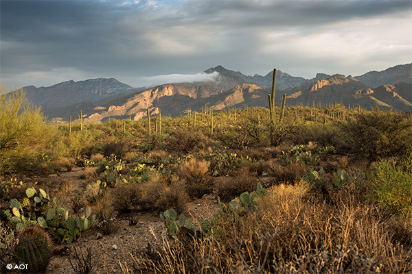
Northeast of Tucson at the base of the Santa Catalina Mountains, is the lush Sabino Canyon Recreation. Sabino Canyon offers a variety of terrain including a paved path or miles of rugged trails to explore. You can hike the area or ride one of the open-air trams. The Bear Canyon Tram goes directly to the trailhead for this 2.5-mile walk to picturesque Seven Falls, which includes several stream crossings. The Sabino Canyon Tram makes numerous stops along its 45-minute route. Several hikes of varying difficulty start along the bus path.
|
|
| |
|
| |
|
And last but by no means least is a sunny hike in Yuma. The Lower Colorado River used to support more than 450,000 acres of wetlands and native forests; by 1986, only an estimated 1,000 acres remained. Starting in 2004, Yuma partnered with the Quechan Indian Tribe to work on restoration, and 350 acres have been restored in Yuma East Wetlands within the Yuma Crossing National Heritage Area.
|
|
| |
|
A three-mile trail begins at Gateway Park and loops through marshes, cottonwoods, and willows. The trail through East Wetlands is unpaved but for an extended hike, follow the paved path heading west from Gateway Park. This route stays close to the Colorado River and is dotted with city parks.
|
|
| |
| |
|
|
| |
Trade:
Katie Gould
kgould@hillsbalfour.com
|
Media:
Fiona Lilley
flilley@hillsbalfour.com
|
|
| |
| |
For visitor guidance due to COVID-19 such as mask-wearing, a list of tourism-related reopenings or closures, and a link to public health guidelines, click here: https://www.visitarizona.com/covid-19/ .
Some attractions are open year-round and some are open seasonally or move to seasonal hours. To ensure the places you want to see are open on your travel dates; please check their website for hours of operation.
|
|
| |
|